Tropical Storm Hanna Graphics
Wind Speed Probabilities last updated Mon, 28 Sep 2026 15:29:26 GMT
Wind Speed Probabilities last updated Mon, 28 Sep 2026 15:29:26 GMT
Wind Speed Probabilities last updated Mon, 28 Sep 2026 15:23:18 GMT
Residents of New York and New Jersey, some of whom could be seen kayaking through flooded streets this weekend, are beginning to clean up but remain under flood warnings after heavy storms slammed the East Coast. Rob Marciano reports.
Wind Speed Probabilities last updated Mon, 28 Sep 2026 15:01:05 GMT
Issued at 1100 AM AST Mon Sep 28 2026 000 WTNT43 KNHC 281500 TCDAT3 Tropical Storm Hanna Discussion Number 1 NWS National Hurricane Center Miami FL AL082026 1100 AM AST Mon Sep 28 2026 Recent scatterometer data shows that the disturbance that NHC has been tra…
Issued at 1100 AM AST Mon Sep 28 2026 000 WTNT33 KNHC 281500 TCPAT3 BULLETIN Tropical Storm Hanna Advisory Number 1 NWS National Hurricane Center Miami FL AL082026 1100 AM AST Mon Sep 28 2026 ...TROPICAL STORM HANNA FORMS IN THE CENTRAL SUBTROPICAL ATLANTIC..…
...TROPICAL STORM HANNA FORMS IN THE CENTRAL SUBTROPICAL ATLANTIC... As of 11:00 AM AST Mon Sep 28 the center of Hanna was located near 36.6, -50.4 with movement E at 17 mph. The minimum central pressure was 1006 mb with maximum sustained winds of about 45 mp…
Issued at 1500 UTC MON SEP 28 2026 000 FONT13 KNHC 281500 PWSAT3 TROPICAL STORM HANNA WIND SPEED PROBABILITIES NUMBER 1 NWS NATIONAL HURRICANE CENTER MIAMI FL AL082026 1500 UTC MON SEP 28 2026 AT 1500Z THE CENTER OF TROPICAL STORM HANNA WAS LOCATED NEAR LATIT…
Issued at 1500 UTC MON SEP 28 2026 000 WTNT23 KNHC 281459 TCMAT3 TROPICAL STORM HANNA FORECAST/ADVISORY NUMBER 1 NWS NATIONAL HURRICANE CENTER MIAMI FL AL082026 1500 UTC MON SEP 28 2026 TROPICAL STORM CENTER LOCATED NEAR 36.6N 50.4W AT 28/1500Z POSITION ACCUR…
Wind Speed Probabilities last updated Mon, 28 Sep 2026 14:41:17 GMT
Issued at 300 PM GMT Mon Sep 28 2026 000 WTNT41 KNHC 281439 TCDAT1 Tropical Depression Fay Discussion Number 34 NWS National Hurricane Center Miami FL AL062026 300 PM GMT Mon Sep 28 2026 Fay continues to produce bursts of deep convection, mainly to the south…
Issued at 1500 UTC MON SEP 28 2026 000 FONT11 KNHC 281439 PWSAT1 TROPICAL DEPRESSION FAY WIND SPEED PROBABILITIES NUMBER 34 NWS NATIONAL HURRICANE CENTER MIAMI FL AL062026 1500 UTC MON SEP 28 2026 AT 1500Z THE CENTER OF TROPICAL DEPRESSION FAY WAS LOCATED NEA…
Issued at 300 PM GMT Mon Sep 28 2026 000 WTNT31 KNHC 281439 TCPAT1 BULLETIN Tropical Depression Fay Advisory Number 34 NWS National Hurricane Center Miami FL AL062026 300 PM GMT Mon Sep 28 2026 ...FAY MOVING SOUTH-SOUTHWESTWARD OVER THE CENTRAL ATLANTIC... SU…
...FAY MOVING SOUTH-SOUTHWESTWARD OVER THE CENTRAL ATLANTIC... As of 3:00 PM GMT Mon Sep 28 the center of Fay was located near 27.1, -44.6 with movement SSW at 9 mph. The minimum central pressure was 1011 mb with maximum sustained winds of about 35 mph.
Issued at 1500 UTC MON SEP 28 2026 000 WTNT21 KNHC 281438 TCMAT1 TROPICAL DEPRESSION FAY FORECAST/ADVISORY NUMBER 34 NWS NATIONAL HURRICANE CENTER MIAMI FL AL062026 1500 UTC MON SEP 28 2026 TROPICAL DEPRESSION CENTER LOCATED NEAR 27.1N 44.6W AT 28/1500Z POSIT…
Forecasters said Hurricane Polo could bring "life-threatening winds and flash floods" to parts of Mexico's Baja California Sur and nearby Sonora on Monday and Tuesday.
Millions remain under flooding threats after a powerful nor'easter pummeled the East Coast with heavy winds and rain over the weekend. Rob Marciano reports.
Hurricane Nolo will continue to strengthen as it moves away from Hawaii, forecasters said, but it was still expected to lash the Big Island and Maui with heavy rain.
047 ABNT20 KNHC 281116TWOAT Tropical Weather OutlookNWS National Hurricane Center Miami FL800 AM EDT Mon Sep 28 2026For the North Atlantic...Caribbean Sea and the Gulf of America:Active Systems:The National Hurricane Center is issuing advisories on Tropical D…
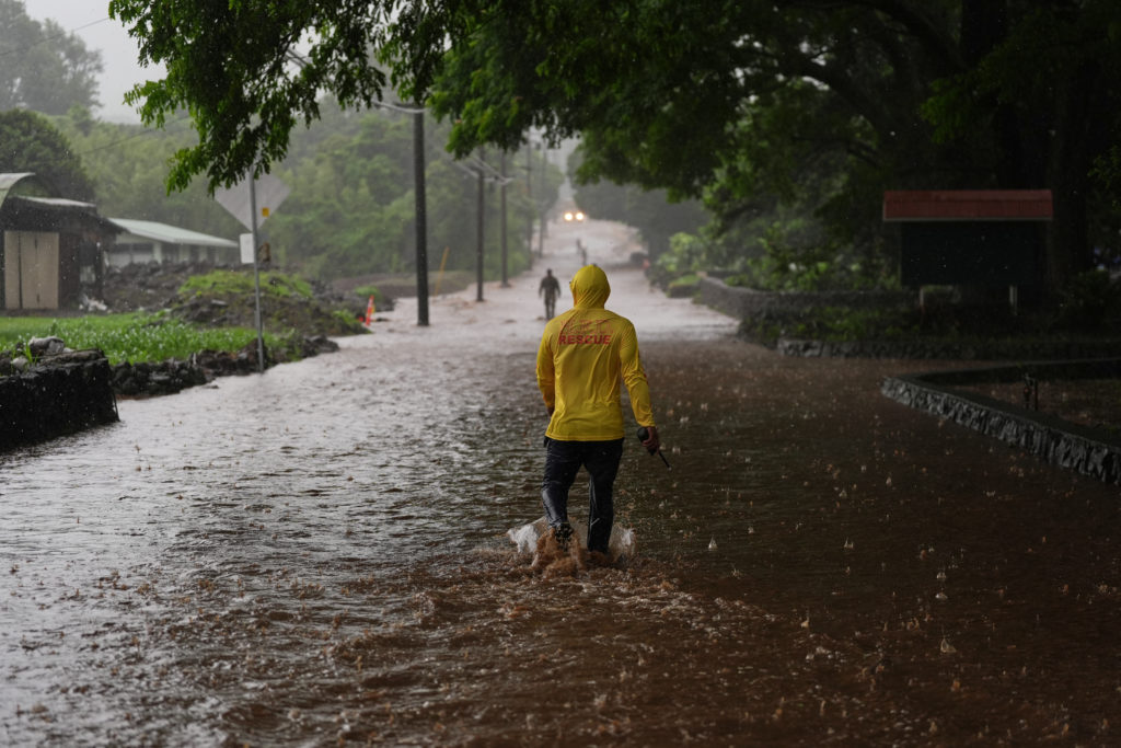
Nolo was expected to continue strengthening and turn toward the northwest by Sunday night, though the National Hurricane Center said the center of the storm would remain well south and southwest of the Hawaiian Islands.
Tens of millions of people are in the path of the storm, which has canceled flights, concerts and sporting events.
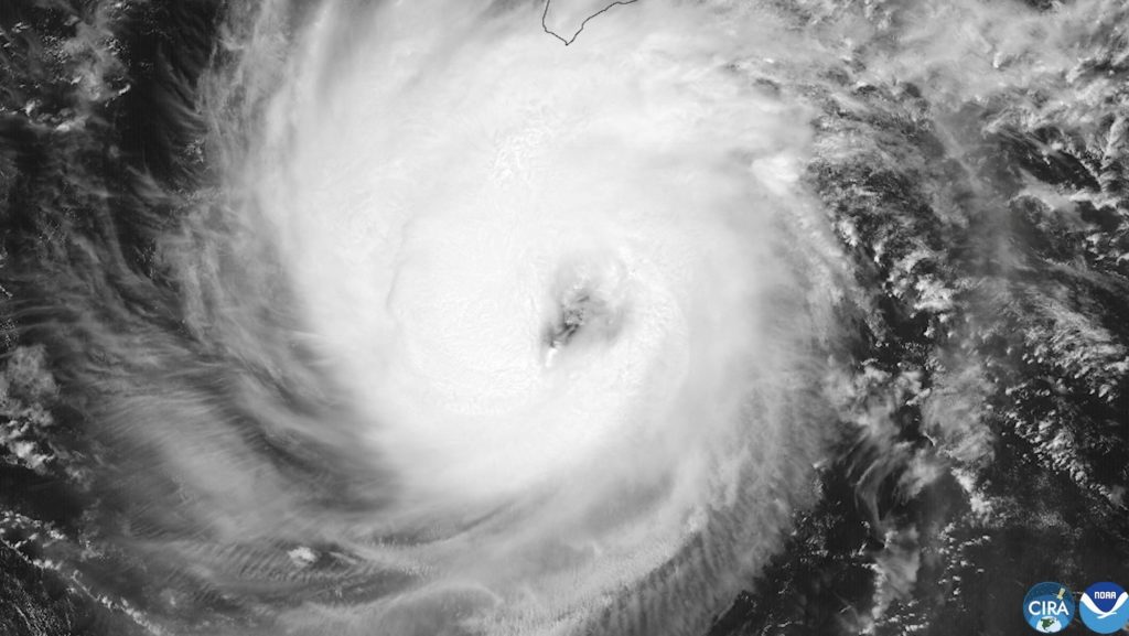
While direct landfall by the storm's center was not expected, forecasters said it could cause life-threatening flooding and mudslides, with parts of the Big Island expected to see rainfall totals up to 20 inches.
The Saffir-Simpson Hurricane Wind Scale rates hurricanes on a scale from 1 to 5.
Colorado State University has updated its annual Atlantic hurricane forecast, predicting nine named storms and four hurricanes may develop during the 2026 season.